The Haunting of an Interred River
Morphology of Urban Form in the Garrison Creek Drainage Basin
Research and Map by Jason Wu
Urban Design 1031: A History of Toronto Urban Form
Professor: George Baird
Fall 2021
Daniels Faculty
University of Toronto
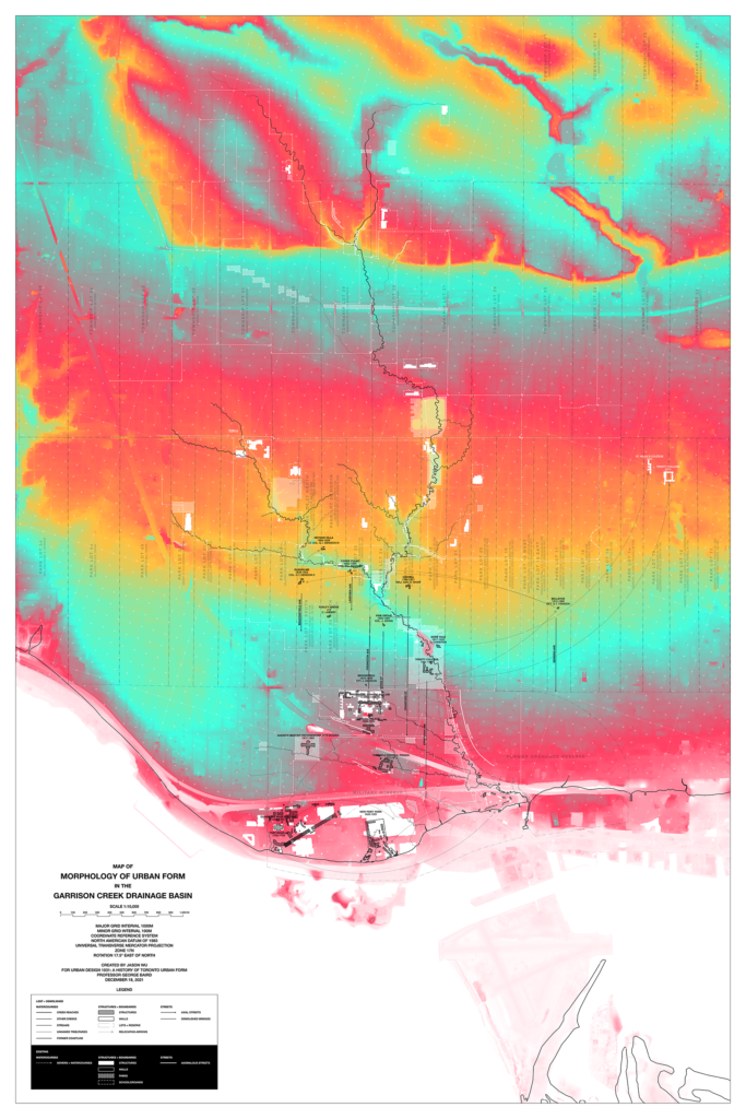
The dip in Dovercourt Road as you approach 14th Division; the sound of an ever-flushing toilet beneath your feet as you walk down Shaw Street at Hallam; the archaic stone parapet along the north side of Harbord Street separating the sidewalk from… grass?1 All of these are remnants of the Garrison Creek, which formerly flowed through the West End of Toronto and emptied into Lake Ontario at a point just southeast of the Old Fort York. Its drainage basin stretches as far as the Toronto West Railpath in the west and beyond St. Clair Avenue in the north. Today, it is largely channelized and flows into the lake via a system of sewers. Pedestrians can spot medallions marking key points where the creek flowed in the past, as well as a map monument at Stanley Park which superimposes the flow paths of the creek upon the present-day urban fabric of the West End.
However, besides these explicit reminders of the lost river, the creek and its tributaries have made their mark on forming the topography of the West End and, by extension, shaping its parks and public spaces, locating its schools and institutions, and creating anomalies in its urban fabric and street grid. The same can be said for the various other creeks which once flows through the Old City of Toronto and are similarly, perhaps hauntingly, hidden in plain sight today. This essay will examine the lasting impression which the Garrison Creek has left behind after its interment in the underground watercourse beneath our parks and streets.
The Garrison Creek and its many tributaries cannot be mapped to exact historical accuracy due to the excessive amount of engineering which Torontonians have applied to the West End landscape in order to permanently erase its path in its urban context. However, the creek has had a phenomenal effect on shaping the amenities and mobility of the West End and, by extension, the culture and collective memory of its residents. With access to historical imagery and with the help of digital tools, we are able to perform some re-tracing of the Garrison Creek’s former appearance and highlight how its historical course has left a lasting impression on this area in the city, just as the many dozen lost Toronto rivers have influenced the morphology and progression of their own parts of town.
[Essay in entirety to be published at later date.]
1 Beth Kapusta, “Infrastructure and Parks: The Garrison Creek Community Project,” Canadian Architect 39, no. 6 (1994): 22.
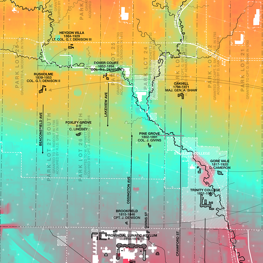
Detail of map showing confluence of Christie Reach (northeast portion) and Denison Creek (northwest portion) into Trinitiy Reach (south portion), with demolished significant buildings and homesteads shown in black.
Bibliography
Brown, James and Kim Storey. “Buried Alive: Garrison Creek as a Rediscovered Extended Waterfront.” In Toronto’s Water from Lake Iroquois to Lost Rivers to Low-flow Toilets, edited by Wayne Reeves and Christina Palassio, 204-211. Toronto: Coach House Books, 2008.
Brown, James and Kim Storey. “Toronto’s Garrison Creek Watershed: Regeneration of a Hidden Waterway.” New City Magazine 15, no. 2-3 (1994): 41.
“Crystal Palace.” CNE Heritage. Canadian National Exhibition. Accessed November 16, 2021. https://www.cneheritage.com/gallery-details-page?image_id=1008&main_category_id=59.
Watts, Dick, P.J. Hare and The Toronto Green Community. “Garrison Creek.” Lost Rivers Walks. Accessed October 8, 2021. https://www.lostrivers.ca/content/GarrisonCreek.html.
Jefferys, Charles W. “Map Showing Position of French Posts at Toronto.” In The Picture Gallery of Canadian History, Vol. 1, 218. Toronto: Ryerson Press, 1942.
Kapusta, Beth. “Infrastructure and Parks: The Garrison Creek Community Project.” Canadian Architect 39, no. 6 (1994): 22.
Lundell, Liz. The Estates of Old Toronto. Erin, ON: Boston Mills Press, 1997.
Moore, Isabel A. “Listening for Lost Creeks: Recollecting Absence via Alberto Caeiro and Eirin Moure.” University of Toronto Quarterly 83, no. 3 (2014): 705-722.
Pollock-Ellwand, Nancy. “The Prolific Interpreter of the Olmsted Vision: Frederick G. Todd, Canada’s First Landscape Architect.” Planning Perspectives 34, no. 4 (2017): 191-214.
Smith, Wendy. “The Toronto Park Lot Project.” The Toronto Park Lot Project. Wendy Smith. Accessed December 17, 2021. https://parklotproject.com/.
Robertson, David A. and Andrew M. Stewart. “The Garrison Creek Mouth and the Queen’s Wharf: Digging Up 200 Years of Shoreline Development.” In Toronto’s Water from Lake Iroquois to Lost Rivers to Low-flow Toilets, edited by Wayne Reeves and Christina Palassio, 146-153. Toronto: Coach House Books, 2008.
Rosenburg, Elissa. “Public Work and Public Space: Rethinking the Urban Park.” Journal of Architectural Education 50, no. 2 (1996), 89-103.
List of Referenced Maps and Data
Argo, John W. Plan to Accompany Report on Garrison Creek Sewer System [map]. 1″ = 1000′-0″. Toronto: Gore & Storrie Limited Consulting Engineers, 1956.
- Sewers.
Biscoe, Vincent. Fort York [map]. 1″ = 80′-0″. Quebec: Royal Engineers Office, 1842.
- Old Fort.
Bonnycastle, R.H. Plan of Comparison shewing, in yellow, the site of the new Barrack and Work around it at A; the Wharf B, and Tower C, proposed for the defence of the entrance of the Harbour of York, the Capital of Upper Canada and a chief Port for commerce on the Lake Ontario [map]. Scale not given. Toronto: Royal Engineer Office, 1833.
- French Fort, former shoreline.
Composite map of the New Fort, circa 1840-1950 within the context of the CNE grounds [map]. 1:5000. Toronto: Archaeological Services Inc., 1995.
- New Fort.
Evans, R.B. Trinity College [map]. 1″ = 100′-0″. Toronto: Parks Department, 1913.
- Trinity College.
Fleming, Sandford A. Plan shewing the Boundaries marked on the ground of the Military Reserve belonging to the Ordnance in the City of Toronto [map]. 1′ = 264′-0″. N.p., 1852.
- Small tributaries of Fort Reach south of King Street.
Fleming, Sandford A. Topographical Plan of the City of Toronto, in the Province of Canada [map]. 12 chains to an inch. Toronto: Hugh Scobie, 1851.
- Trinity Reach meanders north of Queen Street, Denison Creek, Dewson Streem, Brookfield.
Fleming, Sandford A. Verification Plan shewing the Boundaries marked on the ground of the Military Reserve belonging to the Ordnance in the City of Toronto [map]. 1′ = 264′-0″. N.p., 1852.
- Asylum Stream channelized, Stafford Stream, other small tributaries of Fort Reach.
Gaviller, Maurice. Wadsworth & Unwin’s Map of the City of Toronto [map]. 1′ = 300′-0″. Toronto: Wadsworth & Unwin, P.L. Surveyors, 1872.
- Racetrack, estates exempt from taxation (Rusholme, Dover Court, Foxley Grove, Pine Grove, Oakhill, Gore Vale).
Goad, Charles E. Atlas of the City of Toronto and Vicinity. Second Edition [map]. 1′ = 200′-0″. Montreal: Charles E. Goad Company, 1893.
- Trinity College, Provincial Insane Asylum, Mercer Reformatory, Toronto Central Prison, New Crystal Palace, Toronto Island.
Hering, Rudolph G. and Samuel M. Gray. Plan of the City of Toronto, Proposed Intercepting Sewers and Outfall [map]. 1″ = 1375′-0″. Toronto: Copp Clark & Co. Lithographers, 1889.
- Humewood Reach.
Jefferys, Charles W. “Map Showing Position of French Posts at Toronto.” In The Picture Gallery of Canadian History, Vol. 1, 218. Toronto: Ryerson Press, 1942.
Map of the Lunatic Asylum, Toronto [map]. 3 1/8 chains to an inch. Toronto: Ontario Department of Public Works, 1891.
- Lunatic Asylum.
Nicolls, Gustavus. Plan of the Fort at York, Upper Canada, shewing its state in March 1816 [map]. 1″ = 60′-0″. Quebec: Royal Engineers Office, 1816.
- Fort Reach meanders.
Plan of the City of Toronto, Shewing Proposed System of Parks and Boulevards [map]. 1” = 3000’-0”. Toronto: City Engineer’s Office, 1882.
- Extents of Denison Creek, Brock Stream, Moutray Stream.
Plan of the City of Toronto, Shewing the General System of the New Water Works and Position of All the New Pipe Laid [map]. 1” = 3000’-0”. Toronto: Copp Clark & Co. Lithographers, 1876.
- Christie Reach meanders.
Smith, Wendy. “The Toronto Park Lot Project.” The Toronto Park Lot Project. Wendy Smith. Accessed December 17, 2021. https://parklotproject.com/.
- Park Lots.
Tully, Kivas. Provincial Lunatic Asylum, Plan of the Grounds showing the Buildings, Drainage, and Approaches [map]. Scale not given. N.p., 1863.
- Asylum Stream, Old Crystal Palace.
Williams, George. Plan of the Town and Harbour of York [map]. 10 chains to an inch. Toronto: George Williams Royal Military Surveyor & C., 1814.
- Fort Reach meanders.
Williams, George. Sketch of the ground in advance of and including York, Upper Canada [map]. Scale not given. N.p., 1813.
- Small streams west and independent of Garrison Creek.